In a recent article published in Hydrology, researchers from Belgium and Morocco investigated the complex interactions between mine tailings and trace metal contamination in the Upper Moulouya Catchment of Morocco. The study highlighted the importance of understanding trace metal flows due to the environmental and health risks associated with mining activities, particularly in semi-arid regions where soil erosion exacerbates the issue.
Image credit: Wirestock Creators/Shutterstock.com
Background
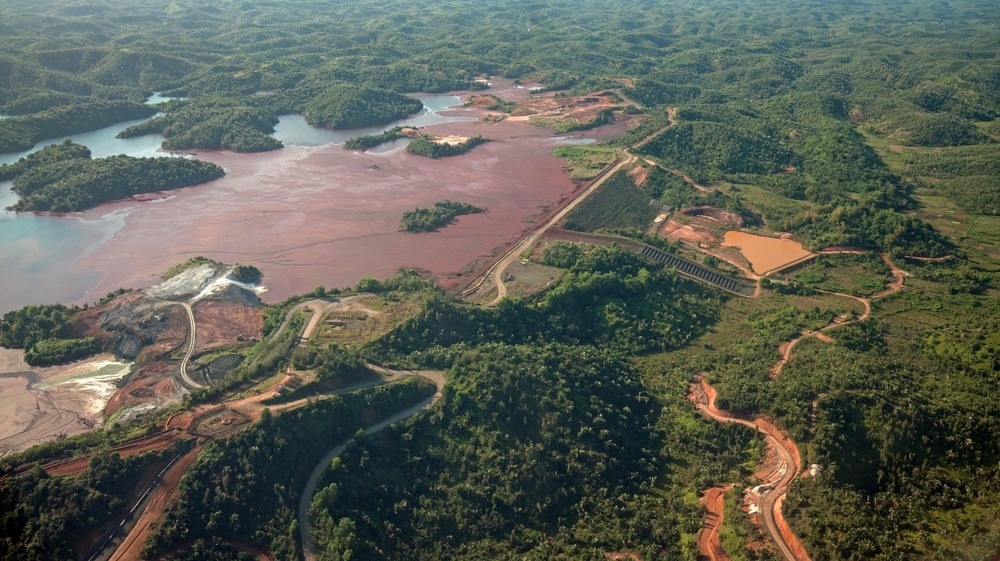
Mining operations often lead to the accumulation of waste, which can release trace amounts of harmful metals into surrounding ecosystems. The Zaida mine, located in a semi-arid area, presents a unique case for studying these dynamics. Previous research has shown that soil erosion can significantly affect contaminant transport, making it important to assess the extent of trace metal fluxes from mine tailings to nearby water bodies. This study aims to fill the knowledge gap regarding the quantification and assessment of these fluxes.
The current study
The research was conducted in the Upper Moulouya Catchment, focusing specifically on the abandoned Zaida mine in northeastern Morocco. The study used the Revised Universal Soil Loss Equation (RUSLE) to estimate the rate of soil erosion. This widely recognized empirical model predicts average annual soil loss based on several key factors.
Rainfall Erosivity (R) data were obtained from local meteorological stations to calculate the erosivity factor. The soil erosion factor (K) was calculated by collecting soil samples from different locations within the watershed to determine their physical and chemical properties. Length of Slope and Slope (LS) were derived using digital elevation models (DEM).
Cover Management (C) data were collected through remote sensing techniques and field surveys to assess vegetation cover and its impact on soil erosion. Erosion calculation was done using the RUSLE equation to estimate soil loss throughout the watershed, allowing the identification of areas with high erosion potential.
To estimate trace metal concentrations, soil samples were collected from the top 15 cm of the soil profile, as this layer is more susceptible to erosion and contamination. Sampling points were strategically selected based on proximity to the mine and hydrologic flow patterns.
Concentrations of trace metals (Pb, Cu, Cd, Zn) were determined using inductively coupled plasma mass spectrometry (ICP-MS) after acid digestion with a mixture of nitric and hydrochloric acids. Several pollution indices were calculated to assess the level of metal pollution in sediments. These included the Geoaccumulation Index (Igeo), the Pollution Load Index (PLI) and the Contamination Factor (CF).
Results and discussions
Application of the RUSLE model revealed an average annual soil erosion rate of 9.1 tonnes per hectare per year (t/ha/year) across the Upper Moulouya catchment. This rate indicates a relatively low level of erosion compared to other regions. However, it remains important given the semi-arid context and the potential for increased erosion during heavy rainfall events.
The spatial distribution of erosion rates pointed to areas of higher susceptibility, particularly those adjacent to mine tailings, where the combination of steep slopes and disturbed soil conditions contributed to increased erosion.
Analysis of soil samples indicated that lead (Pb) was the predominant contaminant, with concentrations exceeding 200 mg/kg in areas directly downstream of the mine tailings. Other trace metals, including copper (Cu), cadmium (Cd) and zinc (Zn), were also detected, albeit at lower concentrations.
The highest levels of contamination were found within a radius of 14 km from the tailings, suggesting that prevailing wind patterns and hydrological transport mechanisms play a crucial role in the distribution of these pollutants throughout the watershed. The results link soil erosion rates and trace metal concentrations.
The geo-accumulation index (Igeo) showed that the sediments in the Moulouya River were moderately contaminated with Pb and Cu, while Cd and Zn showed lower levels of contamination. The pollution load index (PLI) confirmed these findings, revealing that river sediments acted as a sink for trace metals mobilized from surrounding contaminated soils.
The CF analysis highlighted that Pb posed the greatest risk to the aquatic ecosystem, with concentrations significantly exceeding threshold limits set for sediment quality. This elevated level of contamination raises concerns about potential ecological impacts, including toxicity to aquatic organisms and bioaccumulation in the food chain. Additionally, soil pH and organic matter content were found to affect the availability and mobility of trace metals, with lower pH levels associated with higher metal solubility.
CONCLUSION
In conclusion, the study shows that mine tailings in the Upper Moulouya watershed are an important source of trace metal pollution driven by soil erosion processes. The integrated approach in this research provides valuable insights into the dynamics of metal fluxes in semi-arid environments. The authors emphasize the need for continuous monitoring and the implementation of rehabilitation strategies to address the environmental challenges posed by mining activities in such vulnerable regions.
Source:
Mimouni Y, Chafi A, et al. (2024). Estimation of multiple trace metal fluxes in a semi-arid catchment containing mine tailings using a multi-tool approach (Zaida mine, Upper Moulouya Catchment, Morocco). Hydrology 11 (7): 105. DOI: 10.3390/hydrology11070105, https://www.mdpi.com/2306-5338/11/7/105